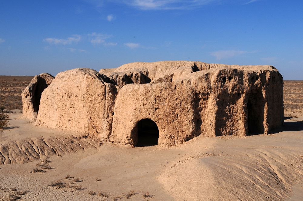
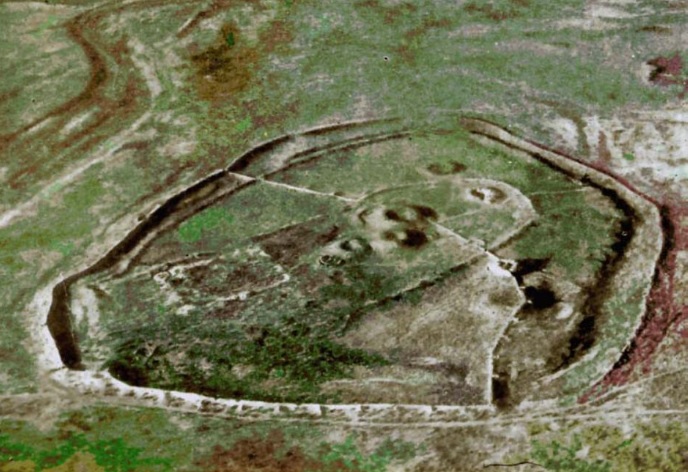
Шірік-Рабат - Қазақстан аумағындағы республикалық маңызы бар тарих және мәдениет ескерткіштерінің мемлекеттік тізіміне енген көне қала орны. Ол шамамен б.з.б. IV-II ғасырлар аралығында және кейінірек б.з. X-XIII ғасырларда өмір сүрген археологиялық кешен ретінде белгілі. Ескерткіш Қызылорда облысы Қармақшы ауданында, Көмекбаев ауылынан оңтүстік-батысқа қарай 87 км жерде, Жаңадария өзенінің сол жағалауындағы биік төбеде орналасқан.
Шірік-Рабат алғаш рет 1946 жылы Хорезм археологиялық-этнографиялық экспедициясы (жетекшісі С.П. Толстов) тарапынан анықталып, 1948-1949 жылдары қайта зерттелді. Кейін 1957-1958 жылдары Ю.А. Рапопорт пен С.А. Трудновская жүргізген қазба жұмыстары ескерткіштің мерзімін нақтылап, оның құрылымы туралы толық түсінік берді. 2004 жылдан бастап «Мәдени мұра» мемлекеттік бағдарламасы аясында Ж. Құрманқұлов жетекшілік ететін археологиялық экспедиция зерттеуді жалғастырып келеді.
Қалашықтың жалпы аумағы шамамен 850x600 метр, пішіні сопақша болып келеді. Етегі екі қатар қорған дуалмен және ені 30-40 метр, тереңдігі 3-4 метр ормен қоршалған. Қалаға кіретін қақпалар негізінен оңтүстік және батыс бөліктерде орналасқан. Ескерткіш бірнеше тарихи кезеңде қайта салынып, әр дәуірдің ізін сақтап қалған.
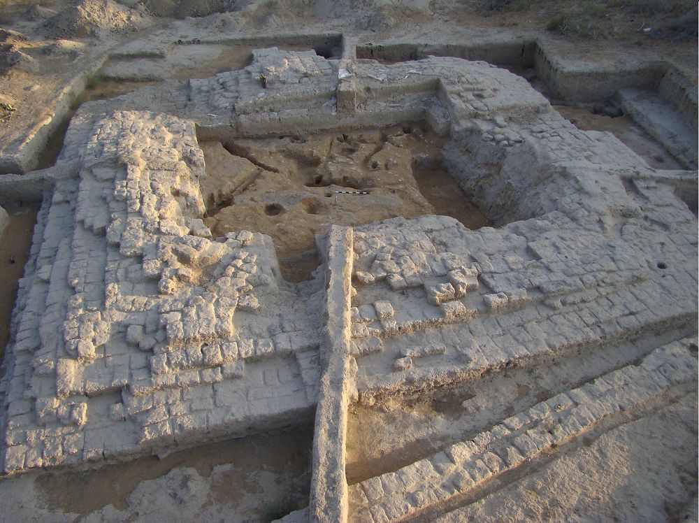
Ең көне кезеңде, яғни б.з.б. IV-III ғасырларда, төбенің ең биік бөлігінде билеушілерге қатысты деп саналатын алты оба орналасқан. Оларды топырақтан үйілген қорғандар қоршап тұрған. Оңтүстік бөлігінде жаугершілік жағдайда паналайтын және қорғандарды күзететін бекініс сипатындағы үйлер болған. Кейінірек б.з.б. III-II ғасырларда күйдірілген кірпіштен салынған ірі сағана, бірнеше мазар және жерасты катакомбалары бой көтерген. Алайда б.з.б. II ғасырда Жаңадария суының тартылуына байланысты қала тіршілігі әлсіреп, бір кезеңде тоқтаған.
Уақыт өте келе, б.з. IX-XIII ғасырлар аралығында аймақта су қайта көбейіп, қала қайта жанданады. Осы кезеңде бекініс құрылымдары күшейтіліп, қабырғалар мен мұнаралар салынған, қабырғаларда атыс ойықтары бар галереялар пайда болған. Қалашықтың қорғаныс жүйесі күрделеніп, әр кезеңнің құрылыс іздері бір-бірімен қабаттаса сақталған.
Шірік-Рабат кешеніндегі ең көне нысандардың бірі - қорғандар. Барлығы алты қорған анықталған, соның төртеуі ертерек кезеңге жатады. Қазба барысында темір семсерлер, скиф типіндегі үш қалақты жебе ұштары, қола жебелер және алтынмен әшекейленген бұйымдар табылған. Бұл олжалар қорғандардың б.з.б. V-IV ғасырларға жататынын көрсетеді.
Жерлеу құрылыстары да өте күрделі сипатқа ие. Ірі обалардың бірінен терең қабір шұңқыры, ұзын дәліз және түрлі қару-жарақ пен әшекей бұйымдар табылған. Олардың қатарында темір семсер, қола жебелер, алтын әшекейлер кездеседі. Кейбір мазарлар бірнеше бөлмеден тұрып, ішінен алтын жапсырмалар, темір қарулар, керамика және қола бұйымдар шыққан. Бұл құрылыстар б.з.б. IV-III ғасырларға тән екені анықталған.
Археологиялық қазбалар барысында ерекше құнды заттар да табылды. Олардың қатарында алтын жапсырмалар, қола қоңыраулар, моншақтар, сүйектен жасалған тарақтар, шыны және тастан жасалған әшекейлер бар. Сондай-ақ сақ жауынгерінің сауыт бөліктері табылып, оның құрылымын қайта қалпына келтіруге мүмкіндік берді. Ең маңызды олжалардың бірі - жазуы бар керамикалық ыдыс, ол Сыр бойындағы ең көне жазу үлгілерінің бірі болып саналады.
Қалашықтың оңтүстік бөлігінде тұрғын үйлер кешені де аршылған. Бұл жерден ошақтар, тандырлар, хумдар, қыш ыдыстар және тұрмыстық заттар табылған. Бұл құрылыс қабаттары негізінен IX-XII ғасырларға жатады және қаланың кейінгі кезеңдегі өмірін көрсетеді.
Жалпы алғанда, Шірік-Рабат Тұран ойпатын мекендеген сақ, массагет тайпаларының жоғары дамыған мәдениетін айқындайтын маңызды ескерткіш болып табылады. Табылған деректер олардың Хорезммен, сондай-ақ Орта Азияның басқа да өңірлерімен тығыз байланыста болғанын дәлелдейді. Қалашық бірнеше тарихи кезеңді қамтып, ұзақ уақыт бойы дамып, кейін табиғи өзгерістер мен өзен арнасының ауысуына байланысты біртіндеп әлсіреген.
Дереккөз: Отырар. Энциклопедия. - Алматы: «Арыс» баспасы, 2005. ISBN 9965-17-272-2